- Topic
- Traffic and demand management
- Country
- Spain
- Resource type
- Case study
First published 08 Sep 2023
The Metropolitan Area of Barcelona approved its Metropolitan Urban Master Plan (PDUM) in March 2023. One it its main aims is to improve the existing road network to ensure more efficient and human-scaled connections, as well as to distribute the available road space to better reflect the diverse needs of users. The objective is to define the metropolis by an urban and social structure where active mobility and public transport have priority instead of the current model of highways and roads planned in the 1970s. One of the main „elements“ of this urban and social structure is the network of “metropolitan avenues”. This concept has been tested in a project for a 6.5 km strip of the N-150 (a national road crossing four municipalities). The choice to pilot the metropolitan avenues in this location was due to its characteristics, including high car use, fractured public space and the presence of multiple barriers that prevented users from easily crossing the road. A second reason was that the responsibilities for managing the N-150 and other transport infrastructure in the area is split between a number of local, regional and national authorities.
The planning process for the metropolitan avenue was led by Àrea Metropolitana de Barcelona (AMB) and undertaken in the context of an URBACT III programme network called RiConnect. AMB designed the work and the planning process in an integrated manner. This involved different groups cooperating closely with each other, including: a core-group to manage the process; a co-creation group for the actual planning; and a commitment group involving political representatives of the different administrative levels to oversee the process. The integrated approach was clearly visible in the definition of the challenges and also in the subsequent work on the vision, objectives and actions. Interdisciplinary teams addressed not solely transport, but urban planning, the regeneration of space and the building stock, the use of heritage and natural assets, as well as the connectivity of neighbourhoods and between municipalities, in order to come to a comprehensive solution.
Starting with a technical analysis by specialists and a qualitative analysis based on a survey of more than 1,100 people, the co-creation group defined the most important issues to address, i.e: to reorganise travel; to reduce the barrier effects of transport and natural infrastructure; to create an inclusive mixed and integrated urban development, employing natural resources; and to establish a governance structure to overcome the fractured responsibilities in the area.
Following a vision exercise, four main project areas were defined in response to the emerging issues that were identified. These addressed: the avenue N-150 and its immediate surrounding area; centres for interactivity and mobility; corridors reflecting the longitudinal characteristics of the area; and making use of the available natural assets as green corridors.
The four main projects were analysed and scored against the objectives of the vision, to identify which project was to be given prevalence, and for which the necessary actions and activities would be identified. The main project focusing on the avenue and its immediate surrounding scored highest and was developed in full detail concerning the responsible authority, the involved stakeholders, the time frame, the objectives connected to the action, funding sources, risks and the single activities to deliver it.
The integrated nature of the planning process was the key success factor to addressing the complex situation concerning the territory and the diverse responsibilities and stakeholder groups that were involved. The planning process ended with the installation of the necessary governance structures for the implementation of the detailed main project on the avenue.
Context
The Metropolitan Area of Barcelona is characterised by its geographic, cultural and economic diversity. It is home to 3.2 million people living in 36 municipalities covering 600 km². Àrea Metropolitana de Barcelona (AMB) is the official public institution for metropolitan cooperation in this large area. Its competences encompass territorial and urban planning, transport and mobility, environment and sustainability, housing, economic development, water and waste management and social cohesion.
Since 2023, the AMB has a Metropolitan Urban Master Plan (PDUM) in place which aims to help the city overcome administrative boundaries and create a vision for the entire area. Within this scope, the existing road network has been identified as a major task for upcoming activities. The PDUM identifies a clear need to create more efficient and human-scaled connections and a fair distribution of available road space between the diverse needs of users. The plan introduces the concept of “metropolitan avenues” for the major thoroughfares and for these it aims to ensure continuity for sustainable mobility, such as public transport and active mobility, to intensify development in the surrounding area, to promote a mix of uses and to create high-quality public space.
For piloting the concept of metropolitan avenues for further projects defined by the PDUM, AMB chose a 6.5 km long strip of the N-150, a national road crossing 4 municipalities in the city. The N-150 in this area has the potential to be a connector between these municipalities (Barberà del Vallès, Cerdanyola del Vallès, Ripollet and Montcada i Reixac). At the start of the project, car dependency was - and yet is - very high, as a result of good connections to surrounding motorways and the poor availability of public transport services. The road itself was oversized and an example of the inefficient use of public space. As a result, it created negative effects, such as high level of emissions, congestion and forming a barrier that those living in the territories of the four municipalities were reluctant to cross. These effects had negative impacts on social relations in the communities. The effect of a barrier in the four municipalities was moreover further increased by railway tracks, the motorway crossing the area and the river Ripoll. Overall, the situation was that of a disconnected, low-quality area with an unclear identity.
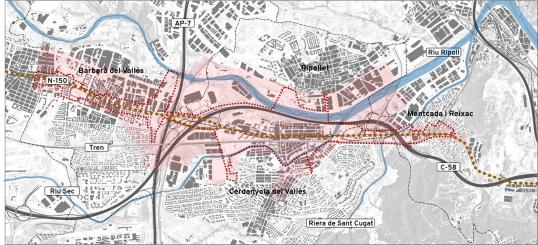
In addition to the challenges presented by the road and other infrastructure, the creation of a metropolitan avenue aimed to address the challenge of the diverse ownership and responsibility for this section of the N-150. Some parts are owned and managed by the respective four municipalities, others, such as the Baricentro hub at the N-150 strip, are owned by the Government of Catalonia. Consequently, working on the project needed to involve different administrations and their respective agencies alongside businesses, civil society and transport providers.
The N-150 was commissioned in 1845 with the aim of creating a straight road to connect Barcelona and Terassa. It carries a clear heritage value as it was designed by Indefons Cerdà, who as well designed the Eixample of Barcelona. The urban centres of the surrounding municipalities developed around it, changing the road’s character over time from a 19th century road without cars to a car-dominated piece of infrastructure that accommodated private vehicles at the expense of social connections and other mobility options.
The main objective of the N-150 project was to structure the territory, rethink the transit infrastructure, promote active mobility and public transport, and improve the continuity of the local network. The four municipalities would be better connected by turning the road into a more permeable and high-quality public space that overcomes the present structural barriers. Ultimately, the project aimed to improve the quality of the neighbourhoods and the overall quality of residents’ life.
The work on the N-150 project was undertaken in the scope of the URBACT III APN RiConnect, led by AMB, to create a co-designed Integrated Action Plan. The idea behind integrating it into a transnational cooperation project was to facilitate the exchange with, and to learn from, other metropolitan areas and to make the most of the programme level guidance for integrated planning and co-creation with the diverse set of stakeholders involved.
In action
The first step was to create a work structure involving the diverse set of stakeholders. The stakeholders were:
- Government bodies: Barcelona Metropolitan Area, Government of Catalonia, the four municipalities with political representatives, heads of departments and municipal specialists.
- Associations: Business, mobility, environmental aspects, residents.
- Scientific stakeholders: Universitat Politècnica de Catalunya-BarcelonaTech.
AMB, as the process manager, set up a project governance structure consisting of four groups: a core group; a co-creation group; a commitment group; and a citizens group:
- The core group took care of the organisation of the process and managed the work of the other 3 groups. Its members were from AMB itself and a representative of each of the other five government bodies involved.
- The co-creation group was at the centre of the work to analyse the situation and produce the vision, objectives and actions. It included specialists on the relevant topic from administrative levels, the associations mentioned above and citizens. Participation of the latter two stakeholder groups varied according to their expertise and interest in the respective work task.
- The commitment group brought together the people who were politically responsible from the governments involved, as well as their respective heads of departments. Their role was to check and ensure that the results of the co-creation groups could be implemented. For this, they were briefed by the core group on a regular basis.
- The citizen group consisted of people living close to the study area. They were specifically involved in open meetings and by means of surveys.
Participation within the groups involved the respective specialist administrations’ teams and the associations, which both worked on motivating and inviting stakeholders. AMB also hired a specialist for the participation process. A large part of the communication used social media channels with LinkedIn directed at specialists and Twitter directed to citizens and local organisations. Local media supported communication at the local level, managed by the AMB team and the communication teams of the local administrations. All in all, 1,999 people took part in the participation elements of the project: 1,168 by survey and 821 by taking part in meetings and open events.
The planning process itself made use of three main elements: the technical, co-creation and co-management areas. The technical area was covered by planning specialists, who did the preliminary research, produced the content framework and analysed the quantitative, qualitative and participatory information gathered during the entire process. The co-creation area brought together all stakeholders. In a first step of five work sessions, the group created a common language to put everybody involved on the same level. It then produced a jointly agreed diagnosis and set objectives for the project. In a second step of a further three work sessions, the group co-designed its proposal for actions to turn the section of the N-150 into a metropolitan boulevard.
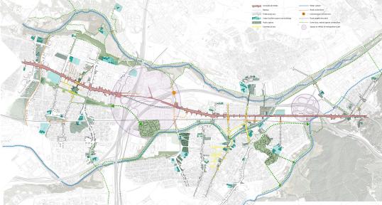
The process started with the analytical part, undertaken by specialist teams for the technical analysis and by the co-creation group and citizens for a qualitative analysis. The technical analysis used a multi-scale approach bringing together territorial elements of the PDUM and the historic development of the area with the more detailed local level, such as looking at trunk roads and their immediate surroundings, the quality of urban space, morphology and present functions.
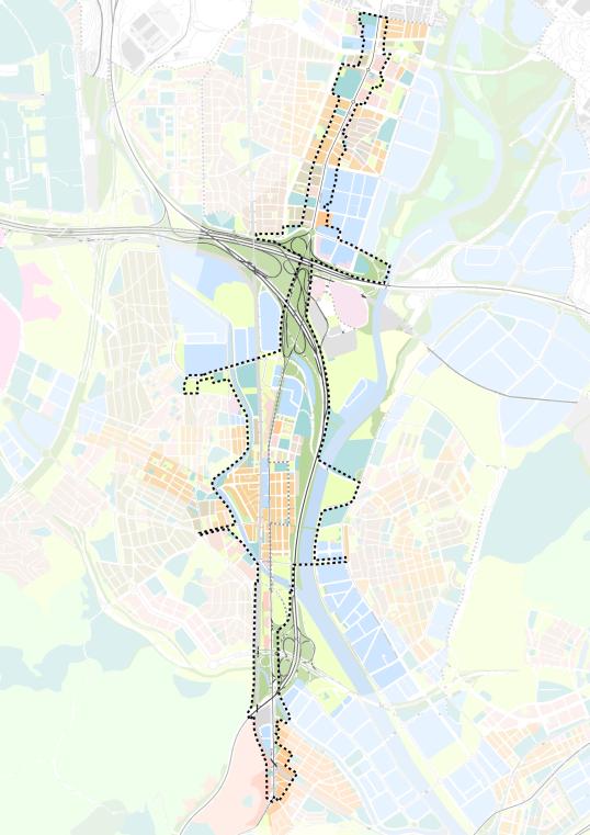
Map of current planning at territorial scale (PDUM)
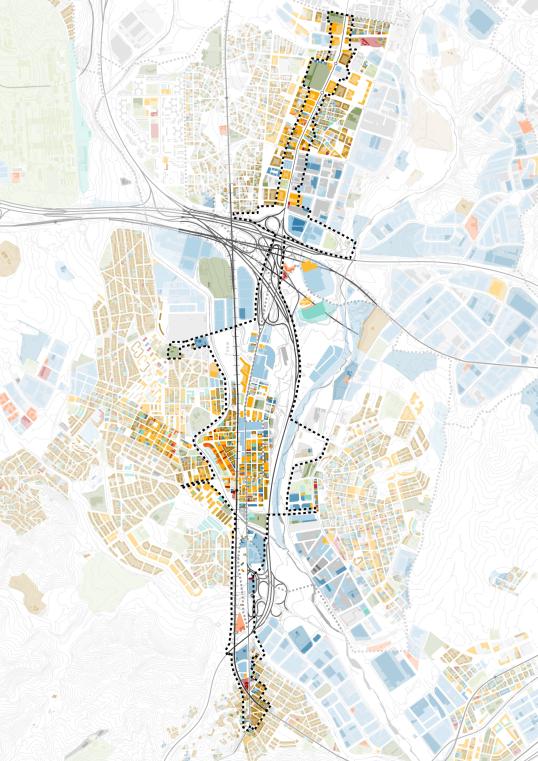
Map of majority uses in ground floor premises
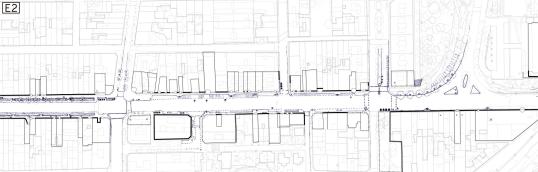
Map of architectural barriers at detail level
The qualitative analysis was undertaken by a survey of stakeholders and citizens on their perception and interests concerning the project area covering mobility, natural assets, pollution levels, urban spaces and the respective need for action. The survey was returned by 1,168 persons and provided the following main feedback:
- Action needed to be taken on and around the N-150;
- The river surroundings needed to be improved and opened to citizens;
- Pollution was a concern from both the motorway and N-150 crossing the area;
- More vegetation was needed on the N-150;
- More space for pedestrians was needed on the N-150;
- More bike lanes and public transport infrastructure and services were needed on the N-150;
- Low-quality urban spaces were considered to be dangerous and unsafe;
- The pedestrian crossing over the railway track needed to be improved; and
- The train tracks themselves were not considered to be a barrier to movement.
A majority of respondents also reported that they travel by private car to work (62.4%) and that they travel by private car to go shopping (61.5%).
The results of the two analytical aspects resulted in the formulation of six emerging issues, i.e. the need to:
- Reorganise travel to meet accessibility and road safety needs;
- Integrate infrastructure to reduce the barrier effect of the present road and rail arteries;
- Plan the area as a mixed and integrated space;
- Add ecosystem functions, so use the present environmental and landscape value of the area as green networks;
- Establish site management governance structures involving the public and private stakeholders; and
- Ensure inclusiveness in the area, in the sense of social inclusion, urban solidarity and liveability.
Following these central emerging issues, the co-creation group created a shared vision for the project area:
The Avinguda del Vallès is the new civic and green corridor for activities that link the municipalities of Montcada, Cerdanyola, Ripollet and Barberà. Public transport and active mobility are the central characteristics of this tree-lined avenue, as well as the meeting places and public spaces that extend and connect the urban fabric of the surrounding area.
It is the theme connecting a renewed, dynamic, diverse and cohesive urban area and a territory rich in industrial, natural and landscape heritage, which is open to innovation, health and leisure.
Its friendly nature and care for the environment in its urban development, restrictions on traffic, and the uses that accompany it make it an avenue on a human scale that provides optimal conditions for liveability, sustainability, proximity, the provision of services, vitality, social inclusion and economic competitiveness.
This vision covers five main objectives to transform the avenue into a connecting, friendly, inclusive, healthy and metropolitan avenue.
An urban strategy addressing three sub-strategies was developed to achieve this vision and the objectives for the avenue, which are as follows:
1) Territorial strategy
Three longitudinal corridors characterise the area, the avenue itself, as well as two green corridors on each side of the road. This strategy is to propose a new territorial structure that links the four municipalities by the longitudinal axes and by transversal corridors between these major long-stretched axes to reestablish links that were severed by them. The transversal corridors make use of existing routes and also set up new routes. They provide meeting spaces for citizens and locate facilities to deliver a greater urban intensity connecting the territory.
2) Local Strategy
The strategy aims to add urban structures that enrich the area around the avenue and the neighbourhoods in the area in each of the four municipalities. It includes improving the permeability of centres to its neighbourhoods, restructuring the avenue itself to improve its connectivity function, introducing new local mini-centres and squares, adding green spaces and refurbishing unused buildings.
3) Mobility Strategy
The strategy aims to divert traffic to other roads to allow a more human scale of the avenue focusing on sustainable mobility modes and to strengthen resilience by distributing traffic volumes across the network. It addresses reducing private mobility as well. The space gained is used to reorganise traffic by adding space for active mobility modes, improving public transport performance and service and replanning car parking.
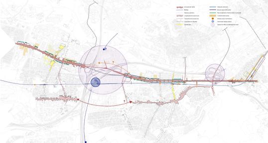
4) Synthesis
This strategy formulates the summary framework by combining the territorial, local and mobility strategies into a joint approach. It is the basis for defining the actions needed to follow-up on the strategic ideas.
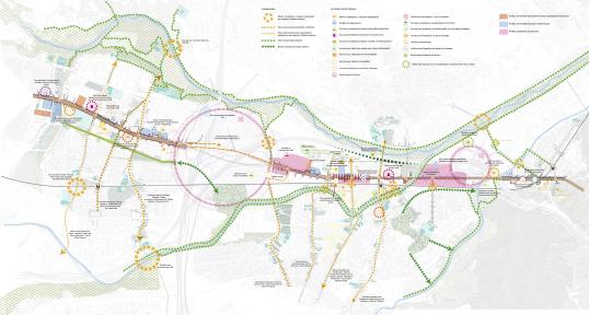
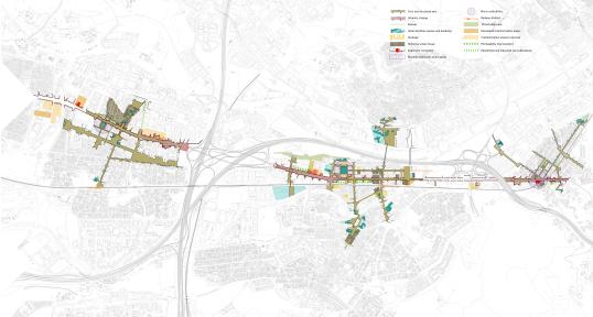
The strategies were delivered by four main projects with 26 specific actions. They address the avenue itself, the central locations for interactivity and mobility, the transversal corridors to re-connect municipalities internally and with each other as well as green corridors exploiting the natural assets of the project area.
Before detailing the actions, some of them were put to the test in a number of smaller pilot activities for a day. Piloting took place in four municipalities and mainly tested what the transformation of the avenue could look like and to what extent people would take ownership of the space alongside motorised transport. Every location had a specific topic.
In the municipality of Barberà del Vallès it was the “connecting avenue”. Tests focused on diverting traffic off the avenue. Part of the avenue was closed to motorised traffic and the space was used for a pop-up cycling lane and active mobility entertainment for visitors, such as a bicycle circuit for children.
In Cerdanyola des Vallès and Ripollet, it was the "friendly and inclusive avenue", a mixed-use approach to the avenue. For this, activities were held directly next to the avenue for visitors to a square, mainly the elderly and children, to learn to what extent mixing functions work without interfering with the road traffic of the avenue.
In Montcada I Reixac the topic was the “healthy avenue”. Parts of the public space directly adjacent to the avenue were used to install temporary greenery alongside information sessions on the topic of health and environment. The traffic on the road was not affected in this location.
A bus service connected the three locations to allow citizens and stakeholders to visit each of them.
Results of the pilot activities were:
- The clear commitment of the elected representatives of the four municipalities was well visible to all stakeholders.
- The road closure in Barberà des Vallès did not result in any major traffic disruptions. The pop-up cycling lane that closed a gap in the network at the avenue turned out to be a feasible action and accompanying measures on cycling promotion were met with high interest.
- The mixed-use approach attracted the interest of elderly and children enriching the ideas for the overall action plan by their views. No problems with the ongoing traffic on the avenue appeared during the pilot.
- Greening the avenue was met with high support from visitors and passers-by who called for their permanent installation to increase the attractiveness of the public space alongside the avenue.
The lessons learnt from the pilot activities were used to define the details of the 26 specific actions.
Results
The four main projects and their 26 subprojects were established within the integrated action plan for the section of the avenue that was the focus of the project. They were prioritised on the basis of their capacity to contribute to the defined objectives. The idea was to decide which of the four main projects to start with first considering the resources and time available. Setting priorities involved first allocating weights to the objectives and their details, using the experience gained in the planning process. In a second step, the four main projects were analysed for their effect on the weighted objectives. As a result, a detailed action plan was developed first for the main project of the avenue. Each action of this main project was detailed in an action table that defined the responsible authority, the involved stakeholders, the time frame, the objectives connected to the action, funding sources, risks and the single activities to deliver the action (see example on action “Redevelopment of Avinguda del Vallès” below). The actions are on:
- The redevelopment of the Avinguda de Vallès to improve the urban quality of the road.
- Connecting the municipalities of Barberà with Cerdanyola and Ripollet.
- Fostering sustainable mobility by introducing public transport services and cycling infrastructure along the entire avenue and reducing heavy vehicle traffic and traffic speed.
- The environmental health programme to reduce the public health impact of the traffic on the avenue.
- Defining the traffic corridor of the avenue to host all modes of transport.
- Preserving and making heritage visible on the historic development of the avenue.
- Promoting local trade and economic activity along the avenue.
- Creating programme ‘spaces of opportunity’ in the area as a result of regeneration approaches.
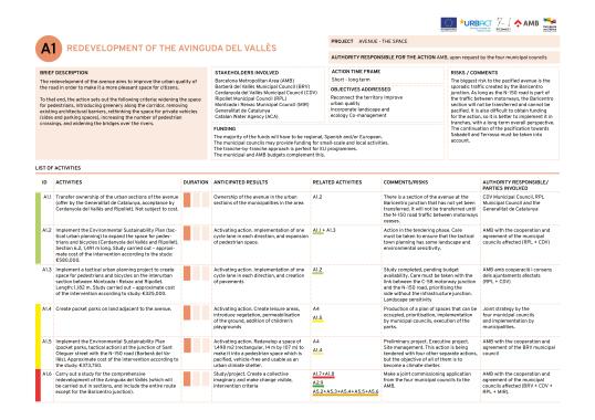
Indicators to measure progress and to monitor implementation were defined alongside the objectives for the project. They form quantitative measurable figures attributed to reference values for measuring the desired outcomes of the project. Each action was attributed with a programme of funding sources additional to existing local and regional ones focusing on European Union programmes.
Finally, the planning process ended with the transfer of the same governance structure to the implementation process. The use of this same structure allowed for an effective delivery of the action plan by including all the involved authorities and stakeholders. A political oversight body is planned, which includes political representatives from the project area. It is responsible for setting priorities between the actions and for adjusting activities and resources as needed. It appoints a project manager to deliver the action plan who is skilled in managing interdisciplinary teams, networks and governance spaces. The project manager brings together the main working body for the implementation phase, the technical monitoring committee, and will lead this group. This committee involves specialists from diverse professions (such as public space, mobility, urban planning, participation, communication) and governance levels (such as local, metropolitan or regional level) and manages the technical implementation of the action plan. It is responsible for setting timelines, monitoring and establishing the needed work structures for each action and its activities. For the latter, the technical monitoring committee will employ territorial working groups involving local stakeholders and citizens to work on specific topics that are outside of the established structures.
Challenges, opportunities and transferability
One of the main challenges for the project was clearly the diverse and fractured set of stakeholders. Public authorities of different governance levels, associations for business, environment, mobility, individuals such as retailers, commuters and residents all had different priorities for the re-design of the avenue in the project area. AMB, as the lead of the planning process, addressed this by installing management, work and decision-making groups that were well interconnected to deliver an integrated planning process. They also hired a team of specialists in participation and communication that helped to organise the participatory and co-creation process. Both moves proved beneficial to the work on the project area as a first pilot of “metropolitan avenues”.
Another challenge was the scope of the project and the novel approach to the re-design of a major traffic avenue in the light of the metropolitan avenue concept. The Metropolitan Urban Master Plan recognised as a major problem the area’s fractured design and responsibilities for main traffic arteries. The planning process again took an integrated approach by widening the topic from improving a road to a territorial approach involving urban development, in order to overcome barriers to create connectivity, to create people-friendly public space designs, and to exploit the natural assets of the area.
Both the challenges and the approaches to these resulted in an integrated planning process that was able to capture the complexity of the task. Framing the work in the URBACT III programme clearly added value to the project and gave inspiration to the planning team from the exchange with peers working on similar planning processes, as well as by the URBACT programme level learning and capacity building activities (see information below).
The use of different, smaller pilot activities was a success as well in terms of obtaining first lessons on the ideas for actions, as well as to expand the level of awareness on the upcoming changes among local stakeholders and citizens beyond the already involved entities and individuals. Although piloting was limited to only one day, it was possible to learn about the co-existence of traffic and other use cases, as well as diverting traffic from the road.
In Depth
URBACT Programme: https://urbact.eu/(link is external)
RiConnet network: https://urbact.eu/networks/riconnect(link is external)
Integrated Action Plan for N-150: https://urbact.eu/sites/default/files/2023-01/riconnect_iap_amb_sq.pdf(link is external)
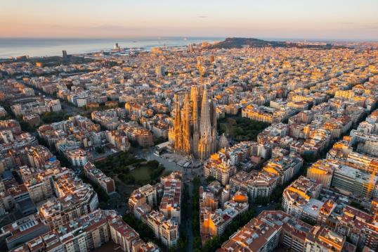
Photo Credit: © Vunav/ Shutterstock.com - no permission to re-use image(s) without separate licence from Shutterstock.